Dishub Nganjuk PJU Management System adalah aplikasi web berbasis GIS untuk mengelola infrastruktur Penerangan Jalan Umum (PJU) di seluruh Kabupaten Nganjuk, Jawa Timur. Dibangun untuk Dinas Perhubungan, sistem ini melacak gardu listrik, tiang lampu, jaringan kabel, dan tagihan listrik PLN bulanan melalui peta interaktif dan dashboard data.
Fitur Utama
1. Manajemen Gardu Listrik
Mendaftarkan dan mengelola gardu listrik dengan data geolokasi, ID pelanggan PLN, nomor meteran, klasifikasi jenis daya (KWH meter vs. berlangganan), kapasitas MCB, dan dokumentasi foto. Setiap gardu berfungsi sebagai titik jangkar dalam jaringan penerangan jalan.
2. Pelacakan Tiang Lampu Jalan
Tiang PJU individual dikatalog dengan jenis lampu (Merkuri, LED, Outdoor, Indoor), watt, koordinat geografis, dan catatan foto. Setiap tiang dihubungkan ke gardu induknya, sehingga mempertahankan hierarki jaringan fisik.
3. Pemetaan Jaringan Kabel
Infrastruktur kabel fisik yang menghubungkan gardu ke tiang lampu dimodelkan sebagai linestring geografis dengan atribut jenis kabel, diameter, dan jarak. Tampilan jaringan ini memberikan visibilitas kepada perencana terhadap topologi distribusi listrik secara keseluruhan.
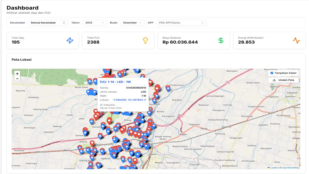
4. Peta GIS Interaktif
Peta berbasis Leaflet dengan pengelompokan penanda menampilkan semua lokasi gardu dan PJU di seluruh kecamatan dan desa/kelurahan Nganjuk. Petugas survei lapangan dan administrator dapat secara visual memeriksa cakupan infrastruktur dan mengidentifikasi kesenjangan.
5. Manajemen Tagihan PLN
Tagihan listrik bulanan dilacak per pelanggan dan gardu dengan dukungan impor CSV untuk entri data massal. Parameter biaya yang dapat dikonfigurasi — jam per hari, harga per kWh — memungkinkan proyeksi biaya yang akurat dan analisis tagihan historis.
6. Dashboard Analitik
Laporan visual menyajikan statistik infrastruktur, tren konsumsi energi, dan ringkasan tagihan. Administrator dapat mengekspor tampilan dashboard untuk pelaporan offline dan presentasi kepada pemangku kepentingan.
Tujuan dan Manfaat
Sistem ini menggantikan pelacakan aset berbasis kertas dengan platform geospasial yang memberikan visibilitas lengkap kepada dinas perhubungan Nganjuk terhadap infrastruktur penerangan jalan mereka. Dengan menghubungkan aset fisik ke lokasi geografis dan biaya listrik, platform ini mendukung perencanaan pemeliharaan, prakiraan anggaran, dan pengambilan keputusan berbasis data tentang perluasan penerangan di seluruh kabupaten.